A knotty old problem: Water exchange and circulation are widespread challenges in human-made lagoons. They have plagued Aquatic Park since its creation during the Great Depression — to avoid a stagnant cesspool when the first version of today’s I-80 was built on fill offshore, to funnel cars to the new Bay Bridge. The new highway cut off a long finger of Bay, back to the old shoreline near the railroad tracks. The Depression-era Works Progress Administration deepened the cut-off finger by dredging, using the soil to create a border of dry land. Here they added a loop road, low shoreline retaining walls of surplus rock or broken concrete, wooden buildings, and restrooms discharging to septic tanks. Today’s network of pipes was installed to let Bay water come and go. The new park was handed over to the city with fanfare and celebrations (bibliography of news reports here).
Berkeley had no sewage treatment until after World War II. Streets, industries, and homes in West Berkeley continued to drain to the lagoons. Within a decade, the new park began to experience smelly algae blooms, mass die-offs, pollution, and shallowing from sediment. Maintenance was neglected — including clearing the pipes that exchange and circulate Bay water. In the 1950s and 60s, dumping to create new land west of the freeway significantly reduced exchange and circulation by permanently blocking the pipe linking the main lagoon’s north end to the Bay. (This fill is now the “Brickyard” portion of McLaughlin Eastshore State Park.) Aquatic Park remained popular, but tinged by an unsavory reputation including crime and then-illegal homosexual trysts. In the early 1960s, the city considered selling it to be filled for industry (bibliography of news reports here).
Since the 1980s, increasingly detailed studies have pointed out the need for action, recommending similar sets of solutions.
All studies have recommended regular maintenance of the existing pipes. Instead, these connections have deteriorated. Several are broken or partly or entirely blocked. Some were cleaned in the early 1960s, about 2011, and in 2020 (using bond funds meant for capital projects). Climate change promises additional difficulties from rising sea levels, more and longer droughts, and storms that dump more water than the city’s storm drains are designed to handle.
The lagoons cannot simply be opened to twice-daily Bay tides, which often rise six feet or more. Instead, pipes, gates, and weirs, their park ends well above average Bay tide levels, limit tidal rise and fall in the main lagoon to about two feet. (The two smaller lagoons can fluctuate somewhat more.) Without these limits, at low tides much of main lagoon would be mud flat, useless to boaters. At high tides and during storms, several buildings would flood.
There has been no action on longer-term solutions. Most would be expensive and complex, requiring permitting and agreements with the railroad, CalTrans, and possibily the East Bay Regional Park District.
In March 2025, Berkeley was awarded a $4.1 million grant to clean and strengthen the pipes that connect Aquatic Park’s main and middle lagoons with each other and the Bay. With the city’s promised match, this would total $5 million. The goal is to improve circulation and keep the old pipes from collapsing and blocking Interstate 80.
The project’s future is uncertain. This was the final grant from a CalTrans program financed mainly by Biden administration programs meant to deal with climate change. The program was ended a year early as administrations changed. So far, the grant has not been withdrawn. Construction, however, remains years away, and Berkeley is delaying many capital projects for lack of money. Complex permitting from CalTrans and the East Bay Regional Park District will be required. Additional federal funds may be needed for construction under I-80.
A web of tide tubes and storm drains:
Water moves into, out of, and between Aquatic Park’s lagoons in complex ways from north, south, east, and west, varying with tides, rainfall, and water levels in the Bay and lagoons. There is no easy way to predict or diagram these interactions. High and low tides in the lagoons, for example, roughly track Bay levels with a lag, but this can vary by several hours. The sections below offer basic explanations.
The image below shows the major water connections to or from land and Bay. It omits small drainages that bring urban runoff from neighboring roads or buildings, recent installation of permeable features from Allston to about Bancroft as part of building the still-empty Berkeley Commons lab building, and planned trash separators east of the tracks at Channing plus a large bioswale in the present Dreamland for Kids parking area. As of late 2025, this project remains active, although replacing the playground is on hold.

The South, Radio Tower Lagoon
The smallest lagoon, much of it hidden by trees, is easy to miss. Its south is privately owned, site of a historic radio tower and station. Its northern portion, though part of the park, is largely cut off by a freeway entrance road. Fencing protects black-crowned night herons that sleep through the day in shrubby shoreline willows. Shallow and seldom disturbed, apparently little changed since at least 1990, it is a haven for other birds as well. CalTrans intends to someday abandon the substandard entrance road, enlarging the park — but has taken no action for years.
This lagoon lacks water connections to the other two. Maps show only two pipes: a local storm drain from the freeway exit road at the south and a connection to the Bay at the northwest corner. This pipe is reported to have partly collapsed more than a decade ago, but water still moves through it in both directions. At very high and low tides, flows into and out of the lagoon circle a marshy island in varied ways that suggest a possible broken pipe or more than one connection. Since at least 1990, a control gate apparently has been inoperative, and the long outlet pipe on the Bay side has lain exposed on the beach — indicating that it may not be clogged with sand. Berkeley’s 2025 grant for improving circulation does not include this lagoon.
Despite shallow, sun-warmed water and mud that can smell of rotten egg from decay without oxygen, this lagoon does not seem to be plagued by the algae blooms that afflict the much larger main lagoon. This may be because it receives little freshwater, nutrient-laden rain runoff from the land.
Clockwise from top left: Sparkling Bay water wells up in marsh vegetation in the south, Radio Tower lagoon. Top right, the concrete box above the lagoon’s NW corner of shows the connecting pipe’s location, above the loop channel where water wells in. Right below, the connecting pipe (yellow arrow) at low tide lies bare on Bay sand a short distance south of the big Potter drain (red arrow). The south pond is not connected to the Potter Drain or middle lagoon. In this photo, the Radio Tower pipe has strong outflow while the Potter Drain is still. Left below, this shallow, isolated lagoon is a haven for water birds and even a deer (green arrow).


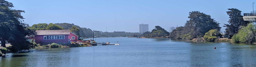
The Middle Lagoon/Model Yacht Basin and Potter Drain
The middle lagoon is separated from the others by the freeway entrance road on the south and the loop road/trail around the main lagoon (Bolivar Drive) on the north. Shoreline seating terraces built from broken concrete and a porthole-style window in the wooden former clubhouse across Bolivar Drive show that the Works Progress Administration’s Depression-Era builders intended this lagoon for the then-popular pastime of racing model sailboats.
The Model Yacht Basin,though a historic landmark, is now much too silted in for these races, as the Google Earth satellite image below shows. Light-colored areas in the image are shallows, some of them islands at low tide. The main lagoon, above it in the image, has no such shoals.
The giant Potter drain: The huge Potter storm drain, 7 ft. high by 9 ft. wide, runs under the freeway entrance road at the bottom of the satellite image, next to the lagoon. It also connects directly into the lagoon at the slight indentation in the bottom right corner, marked with a yellow area. The shoals are the result.

Without this exit into the lagoon, water would back up into low-lying West Berkeley during high tides or storms, flooding streets and properties.
However, besides dirt and other sediment, flow from city storm drains contains a soup of pollutants: gas, oil, heavy metals, micro-plastics, fecal bacteria, and more.
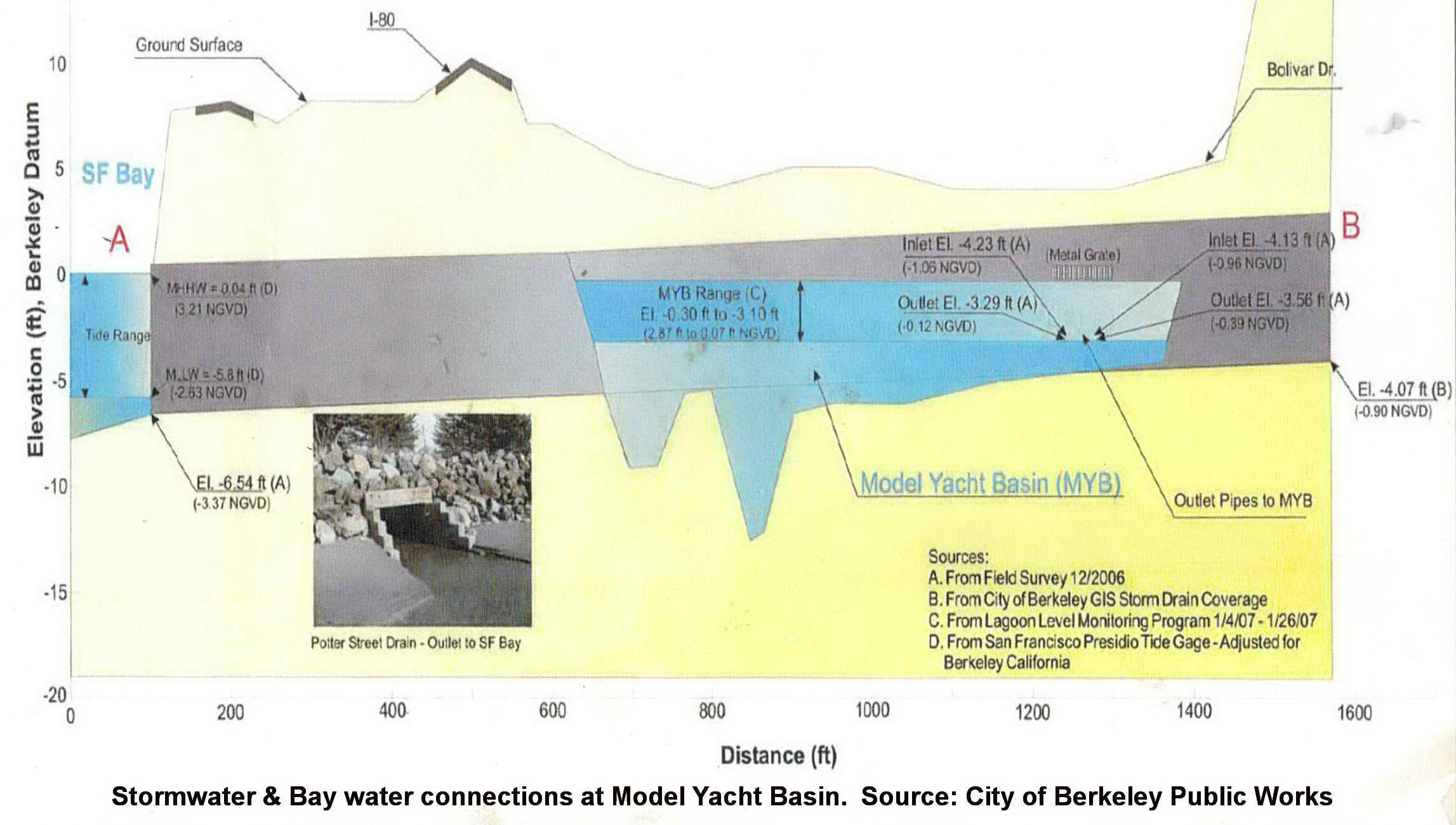
Click here to see a City of Berkeley diagram showing a cross-section through the big drain, in relation to surface and tidal elevation. As the photos below show, water moves between the Potter Drain and Model Yacht Basin fairly freely except when Bay tides are low and there is no rain. Slide gates built to limit flows appear to be permanently open or missing. When water levels are fairly low, flows move in and out via two round openings in the big drain’s side. When tides or storms raise water levels, water also fountains out of grates above the drain.
Clockwise from upper left: Left, during a low and falling tide, water flows from the lagoon into the Potter Drain via two round openings in its side. Center, flows power from these side openings during a rainstorm. Right and below: During high tides or big storms, the drain fills; water also fountains out of wide grates above the drain and flows over its terraced concrete roof.


As the egret hunting in the photo above shows, exchange with the Potter Drain has a silver lining. Bay water flooding up the Potter Drain brings fish and other Bay life. Fish-eating birds –herons, egrets, cormorants, gulls, pelicans, and more — gather to hunt. Frequent exchange with cool, salty Bay water also may be a reason that big algae blooms seem less common here than in the main lagoon, despite pollution from urban runoff.
Long term, and as sea levels rise, the sediment that has gradually filled the Model Yacht Basin from the Potter Drain may also increase flooding in Southwest Berkeley. Berkeley’s century-old storm drains were not built for current conditions — most of the city is now paved or roofed so that rain cannot soak into soil. In a future of higher high tides and larger downpours due to global warming, these storm drains will be more likely to back up and flood streets or buildings. A Model Yacht Basin increasingly filled with sediment will not be an effective outlet or emergency storage. Berkeley is updating its plan for managing stormwater, with a draft expected in 2026. So far, elements considering Aquatic Park are listed as optional; the city has declined to even do simple drone measurements of depths.
The Model Yacht Basin’s choked pipe to the Bay: The Potter Drain did not exist when Aquatic Park. The Model Yacht Basin was built to drain water in and out via a 24″ concrete pipe protected by a concrete box near the middle of its western shore. As the photos below show, this pipe’s lagoon-side mouth now sits well below surrounding silt that also fills much of the pipe. The pipe itself may be broken, like one nearby, not from the box. Unlike the pipe from the Radio Tower lagoon, the Bay end of this pipe was nearly choked by sand by at least 1990. Water is powerful, though. Some flow still muscles through, as the photo at right shows.


Left, photo at low water: Flows through the largely choked 24-inch pipe connecting the Model Yacht Basin and Bay appear to maintain a pit almost surrounded by a bar of sediment. The pipe box is at upper left. The smaller pipe is likely an old drain from the freeway. Center: At low water levels in the lagoon, the dark shape of the 24″ pipe looms below a small whirlpool of outgoing water. Inflows make a small turbulent rise, or boil. Right: On the Bay side at low tide, water bubbles up from sand that all but buries the pipe’s outlet. At very low tides, you can see this outlet, the stairstepped concrete mouth of the Potter Drain, and the Radio Tower pipe close together from the Bay Trail.
As the following sections show, the pollution, circulation, and flooding challenges described above also affect the main lagoon. There is no easy answer. Dredging would be expensive. Many cities with low-lying areas force water to the Bay with pumping stations. Alameda County Flood Control operates two dozen, including in Oakland, San Leandro, and Alameda. Besides costs, however, these require maintenance — not a Berkeley strength. Power to operate pumps also can be lost in emergencies.
Pipes between Model Yacht Basin and main lagoon: Another result of the Potter Drain’s big flows and low side openings is that water levels often fluctuate more and faster in the Model Yacht Basin than in the main lagoon. This is important in exchanging water between the two lagoons. as water flows from a higher level to a lower one until they are equal.
Two large concrete boxes jut from the north shore of the Model Yacht Basin. Each protects an 18″ concrete pipe crossing under Bolivar Drive to the main lagoon. The eastern pipe still carries significant amounts of water, despite breaks and siltation. At right, a current can be seen flowing from the east box into the Model Yacht Basin while water levels in the main lagoon were higher.

On the main lagoon’s side, short pipes project directly from the south shore, without protective boxes. When water is higher in the Model Yacht Basin, you may spot a small whirlpool near the eastern box and vigorous upwelling flow into the main lagoon across the road. As with Potter Drain inflows, this draws fish-eating birds from terns to pelicans, hunting small fish that come with the current, are disturbed by it — or are seeking even smaller prey. Besides fish and other creatures, this eastern pipe may bring significant Bay and/or stormwater nflows from the Potter Drain into the main lagoon.
Below left: In the main lagoon, a great egret and a much smaller cormorant, with snake-like neck, hunt in the boil welling from the Model Yacht Basin connection pipe. Below right: Flows into the main lagoon well up from what looks like a break in the pipe (red arrow) and the actual mouth (yellow arrow). The water’s force maintains a trench in sediments — the light-colored area edged by darker algae.


Until fall 2024, the western pipe appeared completely blocked, with no visible flow at either end. Since then, a small current has been visible flowing into the main lagoon when Model Yacht Basin water levels are higher (photo left). Perhaps tubeworms or other matter blocking the pipe decayed or came loose. Masses of dark green algae, different from surrounding areas, also now flourish near the pipe’s mouth.
Clearing and repairing these these pipes could increase flows, significantly lessening the stagnation and algae growth that plague this end of the lagoon.Another possibility is replacing the failing pipes with a single bridge. This was suggested as the most cost-effective way to improving circulation in a 2007 memo modeling possible improvements to water circulation and exchhange between the two lagoons, part of the major, never-implemented Aquatic Park Improvement Study.
The main lagoon


The main tide gates: The mile-long main lagoon is busy with boaters, its edges popular for picnics, games, cycling, strolling, disc golf, wildlife watching, and more. Their enjoyment hangs on five tide gates (above) near the middle of the western shore, close to the waterski docks and across from the small island visible from the freeway. These gates lead to pipes that angle gently downward to empty at the Bay shore across I-80, a short way south of the long sandy beach. Most of the water that keeps the main lagoon from becoming a stagnant mess moves through these pipes and gates.
The pipes and horizontal openings in the gates keep lagoon water levels from fluctuting more than the desired range of about two feet. When tides in the Bay rise above the bottom of the desired level, Bay water can flow in. Lagoon water below this level cannot flow out. Above this level, openings can be adjusted to allow more or less flow. For example, they can be closed more during extreme high-tide inflows or opened more to let rain from big storms to flow out. This is done manually, and not often. Without this regulation, buildings near the shore would flood at high tides and boats would be stranded on mudflats at low ones.
Inflows bring levels of salt, oxygen, and temperature similar to those in the Bay, so that many of the same or similar plants and animals can survive and move between them. The restricted tidal range, however, combined with low circulation, brings a risk that water in deeper parts of the lagoon can become stagnant, with too little oxygen to support most life.
Flow through the pipes has been seriously restricted at times — most recently by the casings of tiny Australian tube worms. These worldwide invasive “ecosystem engineers” gradually all but filled these and other pipes and ringed the lagoon with what looked like reefs, creating stable, tide-free conditions where they could flourish. With almost no tidal flow, though, water exchange and circulation decreased while algae and smells increased. Clearing them out in 2020 restored tidal fluctuations — but also killed the native oysters. The tubeworms have begun a comeback.
The pipes are almost 90 years old. Their concrete and reinforcing metal are beyond their expected lives and in weakened condition. Collapse, for example in an earthquake, could close I-80 and flood roads and buildings around the main lagoon, as well as in nearby West Berkeley. Berkeley’s $5 million grant to clean and strengthen these and other connections is described in the first section above.
The lost north outlet: Near the north end of the main lagoon, an abandoned concrete box still contains some of the machinery that controlled the WPA’s northernmost pipe to the Bay. It was blocked by the 1950s and 60s rush to fill the shallow waters west of the freeway. The intent was development, but thanks to 40 years of citizen effort, first to stop the fill and then get public access, it is now a park.
Some water may still seep through, visible in a ditch between the Bay Trail and the park. But restoring the connection seems unlikely.

Loss of this pipe’s circulation and exchange, along with shallow depths, are likely reasons why scummy algae is common in the lagoon’s north end. For more on the roles of algae, runoff, and circulation, see Change and Instability.
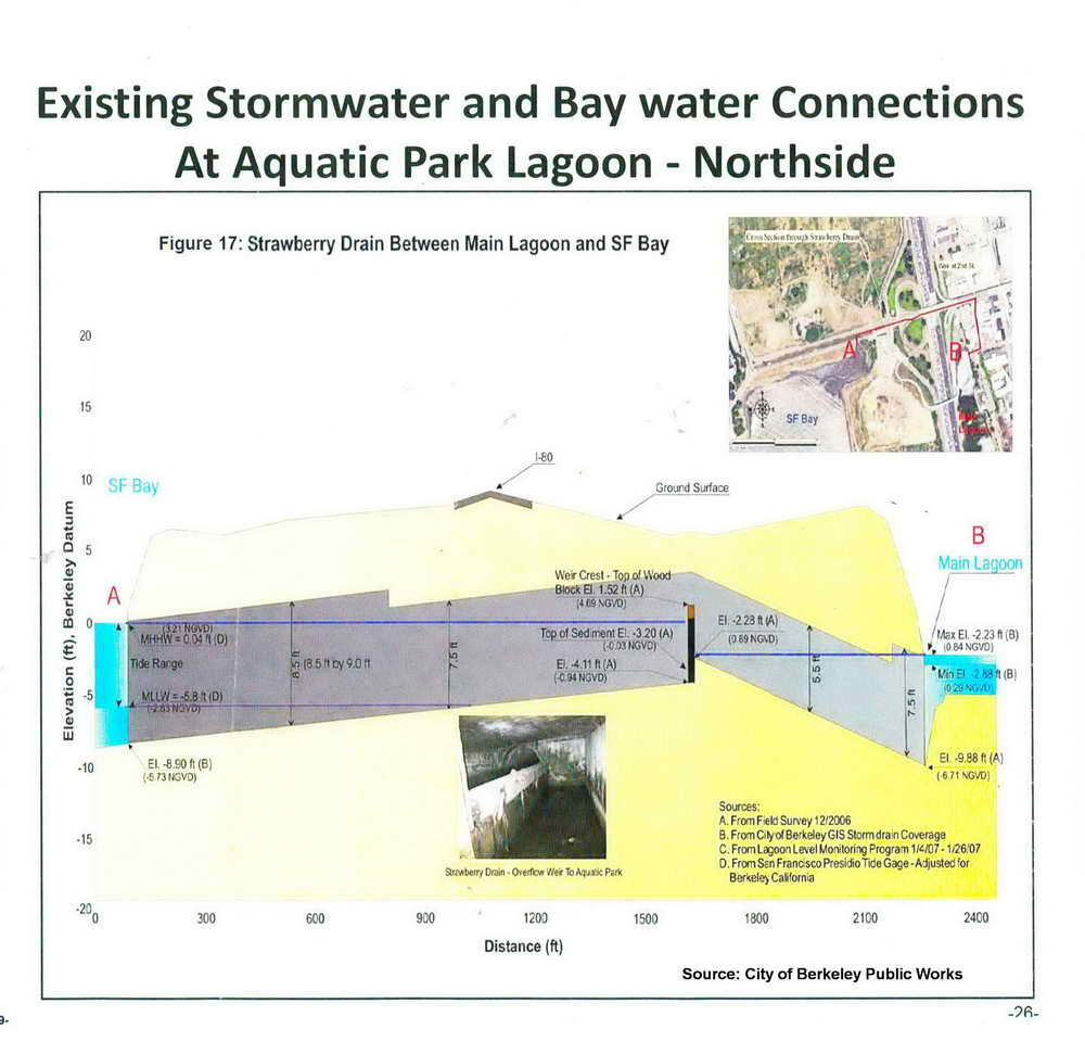
The Strawberry connection: Like the huge Potter Drain at Aquatic Park’s south end, the big Strawberry Drain plays a complicated role in the north. The city’s second-largest storm drain roughly follows the old path of (mostly buried) Strawberry Creek down University Avenue, reaching the Bay at a small cove in McLaughlin Eastshore State Park just west of the freeway. Draining close to a third of the city, the Strawberry drain can flood low-lying property when heavy rains or high tides fill and back up the pipe. A buried spur flowing into the main lagoon at the end of Addison Street helps avoid this.
Click here to see a large City of Berkeley diagram of this spur, almost a half mile long and slightly larger than the Potter Drain at its upper end. As it nears Aquatic Park, it narrows. At the angle where it narrows, a weir –a low dam designed to let water flow over its top — keeps the lagoon from draining northward into the Bay and allows water into the lagoon only when high tides or heavy storms almost fill the drain, threatening backups. At these times, water can be seen boiling up from the pipe’s end.
As in the south end, birds lie in wait, dive, or hunt on the wing here in and near these upwellings, and small silvery schooling fish seem to flash as they jump. The inflows of clean, salty Bay water boost circulation and help make up for loss of the north end culvert. Also as at the south end, however, in storm season this flow brings silt and polluted urban runoff from the city. In summer, the weir seems designed to trap stagnant water. This may contribute to the heavy growths of dark algae that commonly edge the pipe’s submerged end in the lagoon.
Below left: Cormorants dive for fish in the upwelling from the Strawberry Creek drain outlet at the north end of the main lagoon. Pelicans, herons, egrets, and terns also often hunt here during inflows, and flashes of tiny leaping schools of fish are common. Below right: The outlet pipe also often has heavy growths of algae.


Mini-watersheds along the east shore: Multiple small and complex sources of runoff and pollution come from the streets a few blocks east of the park, between the big Potter and Strawberry drains. Although these “mini-watersheds” are not major sources of freshwater runoff, their runoff can carry significant pollution.
In the diagram of pipes and drains at the top of this page, a red line labeled “transite storm drain line” runs from the Potter Drain, on the inland side of Bolivar Drive, north about half the length of the main lagoon, endint across from the tide gates. This was installed in the 1970s, as laws and citizen interest in the environment strengthened — and particularly after the 1972 federal Clean Water Act required states to deal with pollution coming from pipes, and California gave Regional Water Quality Control Boards the task of dealing with industries and local governments. “Transite” is the pipe’s material – – a hard, durable concrete made from Portland cement and asbestos until the 1980s.
The pipe’s aim was to intercept the polluted runoff from industrial West Berkeley, sending it to the Bay via the Potter Drain instead of Aquatic Park’s lagoons. This meant that some of this pollution was bound to wind up in the Model Yacht Basin via the Potter Drain openings there.
In addition, the pipes from the west ends of Heinz, Grayson, and former Carleton Streets (now part of Bayer) still continue west past the transite pipe to the main lagoon. Modern permits strictly limit what industrial discharges may contain and require that they go to the sanitary sewer system, not storm drains.
But when high tides or storms raise water in the Potter Drain, the transite pipe backs up and these storm drains come back to life. At the Heinz Street outlet, water jets forcefully and noisily a long way into the lagoon. The Grayson Street outlet, a heavy-duty raised concrete structure, flows less often, but a trench in the sediments in front of the pipe mouth shows that fairly frequent flows are likely. In extreme cases, as when high tides come with storms, water erupts out of the old iron infrastructure in the park. This is likely to become more common as sea levels rise and large storms become more common, as is predicted.


Left, at high tide, water jets forcefully from the old Heinz Street storm-drain outlet across from the rowers’ boathouse. Above right, strong flow from the old Grayson Street outlet during a storm and King Tide December 14, 2024. Below right, water erupts from the old infrastructure leading down from Grayson Street during this same storm and high tide.
Other aspects of the old infrastructure also raise questions about its safety, condition, and what may be winding up in the lagoon. A recent walk with city staff found two heavy iron covers unsecured and ajar, above deep chambers with water below. Aside from obvious danger, anyone could be dumping anything. As mentioned above, discharges from the Grayson Street outlet, a quarter mile from the Potter Drain, should be few and small. What keeps a more or less permanent trench gouged in the sediments?


Below left: Left, open iron cover over deep, water-filled chamber at west of Heinz Street. Center, another cover ajar west of Carleton Street end. Right, trench in sediment at mouth of Grayson Streeet outlet.