A knotty old problem: Water exchange and circulation are widespread challenges in human-made lagoons. They have plagued Aquatic Park almost since its hurried creation during the Great Depression — to create jobs and avoid a stagnant cesspool when the first version of today’s I-80 was built on fill offshore to funnel cars to the new Bay Bridge. (See Making Aquatic Park — a quick picture history.)
The park they made has three lagoons, separated by roads. The large main lagoon covers about 60 acres; the two smaller south lagoons are each about four acres. These lagoons cannot be simply opened to twice-daily Bay tides, which often rise and fall six feet and more. Boats marooned on bare mudflat do not make an attractive park. The lagoons also must exchange water with the Bay or they would soon become stagnant, smelly, and dead.
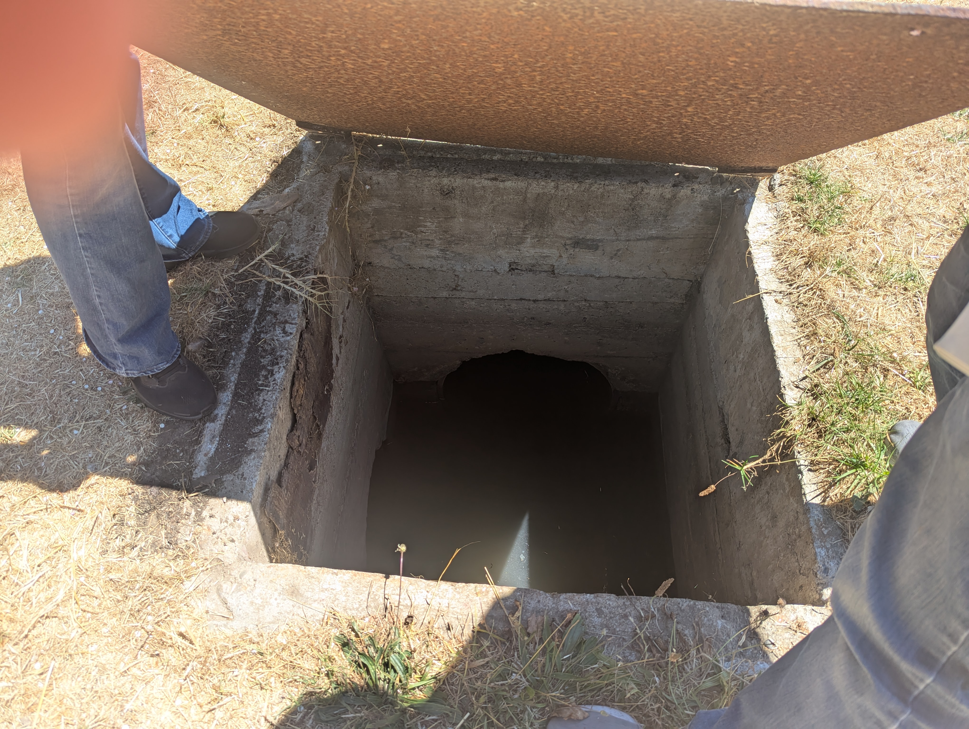
The pipe network: A network of pipes was intended to provide the needed exchange. The original network had ten such pipes. Eight connected lagoon and Bay; One at the north end of the main lagoon (blocked by later landfill west of I-80), five large ones near the center, and one each in the two smaller lagoons (the one in the middle lagoon now largely choked by sediment). These pipes were built with their their lagoon ends above average Bay tide levels and their Bay ends resting on sand exposed at lowest tides. Water flows in or out when Bay tides are above average or levels in a lagoon are above the current level in the Bay. Most of the time, this limits tidal rise and fall in the main lagoon to about two feet. However, it also risks trapping deeper waters that become airless and lifeless. The two small lagoons at the south end can fill faster and fluctuate more.
The pipes also mean that very high tides and heavy or prolonged rainfall can cause floods. The original pipe network had gates and valves that could be opened or closed to keep water out during storms or very high tides, or let more water out before or after them. These now function only for the five central pipes in the main lagoon. The two pipes connecting the main and middle lagoon are largely choked by sediment and may be broken.
Major roles today are played by the city’s huge Potter and Strawberry storm drains, close to 100 years old and increasingly connected to Aquatic Park’s lagoons in the decades since the park was built. These in some ways contribute fresh Bay water and lessen flood danger, but in other ways bring more pollution and sediment and threaten to worsen floods in prolonged heavy deluges that seem to be more likely with global warming.
Problems within a decade, and why: The quickly built park was handed over over to the city with fanfare and celebrations in 1937 (bibliography of news reports here). Problems with smelly algae blooms, fish die-offs, pollution, and shallowing from sediment began to draw attention after the end of World War I . There were many causes:
- EBMUD’s huge pipeline along the railroad tracks, built during WW II, intercepted Berkeley’s and other waterfront cities’ raw human and industrial sewage — basically from indoor plumbing, often called “sanitary sewage.” This had been carried out into the Bay in big outfall pipes. The interception greatly reduced Bay pollution and the “big stench” along the Bay shore. In many ways, it made today’s shoreline parks possible. The outfall pipes would now carry only urban runoff, from street drains, creeks, rain, irrigation, and surface spills or discharges. Runoff, however, still carries both pollution — a soup of contaminates along with dirt and leaks from the “sanitary” sewers. Storms and high tides also can fill these pipes so that water backs up and floods the flatlands. To avoid this, from the 1950s on Berkeley allowed increasing amounts of runoff from the University (Strawberry Creek) and Ashby (Potter Creek) outfall pipes into Aquatic Park’s lagoons. These big outfalls together drain well over half of the entire city, hills to Bay. That is a lot of pollution, dirt and other sediment, plus enough fresh rainwater to quickly turn lagoons from salt to fresh, killing trapped marine life.
- Streets, homes, and heavy industries in West Berkeley near the park continued to drain into Aquatic Park’s lagoons. The park’s restrooms, draining to septic tanks, leached into lagoon waters. Both contributed pollution and encouraged scummy, smelly algae (actually a mix of algae, diatoms, and bacteria, much of it floating because it is dead).
- On the Bay side, sand brought by wind and currents buried or partly choked the ends of the pipes meant to bring water into the main and middle (Model Yacht Basin) lagoons, limiting flow.
- Sediment from Bay inflow, urban runoff, and annual algae growth made the lagoons shallower, limiting exchange. Shallow water generally admits more sunlight and warms more quickly, increasing growth of algae. This can become a vicious circle.
- The lagoons’ pipes were not cleaned regularly. They appear to have been cleaned in the early 1960s, about 2011, and for the five central pipes in 2020 (using bond funds meant for capital projects, after reef-building Australian tube worms had blocked flow, causing serious stagnation. Other pipes were left blocked.)
- The Santa Fe Railroad had owned the Aquatic Park tidelands but traded them for others when the park was built. In the 1950s and 60s, it filled its tidelands west of I-80 in today’s Brickyard area. This permanently blocked the pipe that had exchanged water at the north end of the main lagoon.
The first talk of selling and filling the park, in 1949, ended quickly. A meeting drew mass protest including schoolchildren. It also was pointed out that the Santa Fe Railroad, when it traded its Aquatic Park tidelands, required that they be returned if the area ceased to be a park. Sale and fill came up again in the early 1960s, at the beginning of the long, slow revolution that turned the city’s goals away from Bay fill and toward nature and huge waterfront parks. With pressure from Save Aquatic Park, organized in 1962, the city cleaned the pipes and made improvements designed to draw users. This did not solve the underlying problems of circulation and exchange.
In 1971, the Regional Water Quality Control Board, a state agency gradually increasing its power, ordered Berkeley to keep urban runoff out of the Aquatic Park lagoons. This order, though never repealed, has also not been enforced. The city built a pipe designed to intercept runoff from industries and homes near the west shore of the park and divert it to the big Ashby outfall pipe (now called the Potter outfall or drain.) As the photos below show, this diversion has been partly successful. The order may have begun a long parade of studies with few results.
The parade of studies: In the 1980s, as UC Berkeley established environmental-studies programs. Honors students taught by geologist and paleontologist Doris Sloan did pioneering reports still used today. From 1990 on, the City of Berkeley has paid for a series of increasingly expensive studies and plans for the park: A master plan in 1990, a major technical report in 1994, a 2003 Natural Resources Management Study, followed by the detailed Aquatic Park Improvement Plan, carried through to a huge Environmental Impact Report, 2006-2012. None has been followed by significant action or long-term solutions. (All are available at the links shown.)
Studies and consultants have consistently pointed out that the original pipe network did not provide enough exchange and circulation, and that regular cleaning of the pipes would help. This has not happened.
The plans consider a variety of more extensive and expensive solutions. Many would interfere with other infrastructure. They would require extensive permitting and agreements with the railroad, CalTrans, and possibly the East Bay Regional Park District. Because hydrology is complicated, outcomes can be hard to predict. For example, replacing the old, almost non-functional pipes between the main and middle lagoons with a wide bridge might decrease, rather than increase, circulation, because levels would equalize quickly, with less flow between lagoons. Cutting or removing the native aquatic wigeon grass might increase rather than decrease scummy growth. Climate change promises more complications from rising sea levels, more and longer droughts, and larger storms.
What will a new grant achieve ? In March 2025, Berkeley was awarded a $3.8 million grant to clean and strengthen the pipes that connect Aquatic Park’s main and middle lagoons with each other and the Bay. With the city’s promised match, this would total about $5 million. The goal is to improve circulation and keep the old pipes from collapsing and blocking Interstate 80.
This was the final grant from a California Transportation Commission (includes CalTrans) program financed mainly by Biden administration programs meant to deal with climate change. The program ended a year early as administrations changed. So far, the grant has not been withdrawn, but planning has not begun, complex permitting would be needed, and construction remains years away if it occurs. Additional federal funds might be needed for work under I-80. Berkeley is is delaying many capital projects for lack of money or staff time. The city’s draft capital-improvements plan calls for spending about half the grant in the two years beginning July 1, 2027, but nothing beyond that.
Understanding the web of tide tubes and storm drains
Water moves into, out of, and between Aquatic Park’s lagoons in complex ways from north, south, east, and west, varying with tides, rainfall, and water levels in the Bay and lagoons. There is no easy way to predict or diagram these interactions. Below are basic explanations.
The image below shows the major water connections to or from land and Bay. It omits much of the east side, with small drainages that bring urban runoff from neighboring roads or buildings, recent but not yet approved permeable features from Allston to about Bancroft as part of building the still-empty Berkeley Commons lab building, and planned trash separators and a large raingarden that have grant funding but, like many city projects, are well behind schedule as the city faces serious fiscal problems.

The South, Radio Tower Lagoon
The smallest lagoon is easy to miss. It covers less than four acres, much of it hidden by trees. Although Berkeley now owns the surrounding land, the historic radio tower and station are privately owned. A freeway entrance road cuts off access to the north shore. Fencing protects black-crowned night herons that sleep through the day in shrubby shoreline willows. Shallow and seldom disturbed, apparently little changed since at least 1990, it is a haven for other birds as well. CalTrans says it intends to someday abandon the substandard I-80 entrance road on the south, enlarging the park — but has taken no action for decades.
This lagoon has no water connections to the other two. Most maps show only two pipes: a local storm drain from the freeway exit road at the south and a connection to the Bay at the northwest corner. There may be several more. A control gate on the pipe to the Bay apparently has not worked since at least 1990, and the pipe was reported to have partly collapsed. Nevertheless, water moves through it in both directions, circling a marshy semi-island at very high and low tides. On the Bay side, the long inlet-outlet pipe lies exposed on the beach, apparently not clogged by sand. The 1990s studies attribute this to a slight angle in the shoreline that results in winds and waves not piling up sand. These studies also recommend letting this this isolated lagoon continue to harbor birds while it follows nature’s usual path, filling in to become marsh or meadow.
The lagoon seems in no hurry to become full-fledged marsh, although it remains shallow, with mud that smells of rotten egg, indicating decay without oxygen. Its survival may be because it continues to get inflow of clean, salty Bay water but relatively little fresh, nutrient-laden runoff from the city. Berkeley’s 2025 grant for improving circulation does not include this lagoon.
Clockwise from top left: Sparkling Bay water wells up in marsh vegetation in the south, Radio Tower lagoon. Top right, the concrete box above the lagoon’s NW corner of shows the connecting pipe’s location, above the loop channel where water wells in. Right below, the connecting pipe (yellow arrow) at low tide lies bare on Bay sand a short distance south of the big Potter storm drain (red arrow). The south pond is not connected to the Potter pipe or middle lagoon. In this photo, the Radio Tower pipe has strong outflow while the Potter storm drain is still. Left below, this shallow, isolated lagoon is a haven for water birds and even a deer (green arrow).


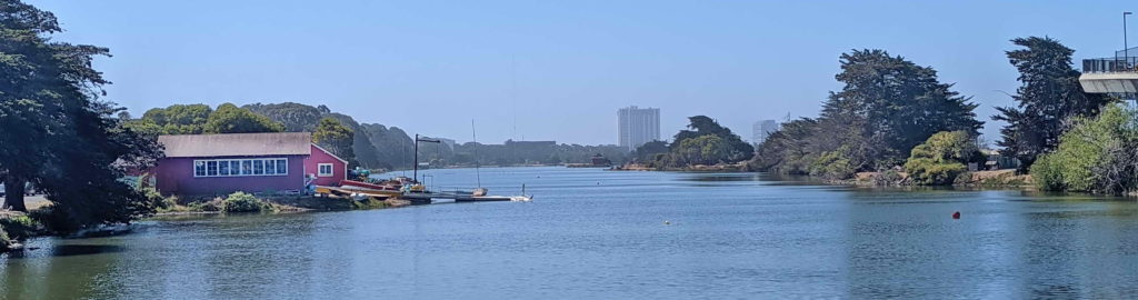
The Middle Lagoon/Model Yacht Basin and Potter Drain
The middle lagoon is separated from the others by the freeway entrance road on the south and Bolivar Drive, the loop road/trail around the main lagoon, on the north. Shoreline seating terraces built from broken concrete and a porthole-style window in the wooden former clubhouse across Bolivar Drive show the Works Progress Administration’s low-cost customizations for the then-popular pastime of racing model sailboats.
Today this Model Yacht Basin, the clubhouse, and the broken flagpole base that once welcomed patriotic pageants are historic landmarks. But the lagoon is much too silted in for races, as the Google Earth satellite image below shows. Light-colored areas in the image are shallows, some of them islands at low tide. The main lagoon, above it in the image, has no such shoals, though since th 1990s studies have pointed out its loss of depth.
The giant Potter pipe: The huge Potter storm drain, 7 ft. high by 9 ft. wide, runs between the lagoon and freeway entrance road at the bottom of the satellite image. It connects directly into the lagoon at the slight indentation in the bottom right corner, marked with a yellow area. The shoals are the result. The slide gates installed to limit or prevent this inflow were reported missing or inoperative in the 1990s. They may have been that way back to the 1950s, when the city increased the amounts of runoff channeled into the park.

Without this exit into the lagoon, water would back up and flood low-lying West Berkeley streets during high tides or storms.
However besides dirt and other sediment, flow from city storm drains contains a soup of pollutants: gas, oil, heavy metals, micro-plastics, fecal bacteria, and more. Bay water at high tides brings much more sediment.
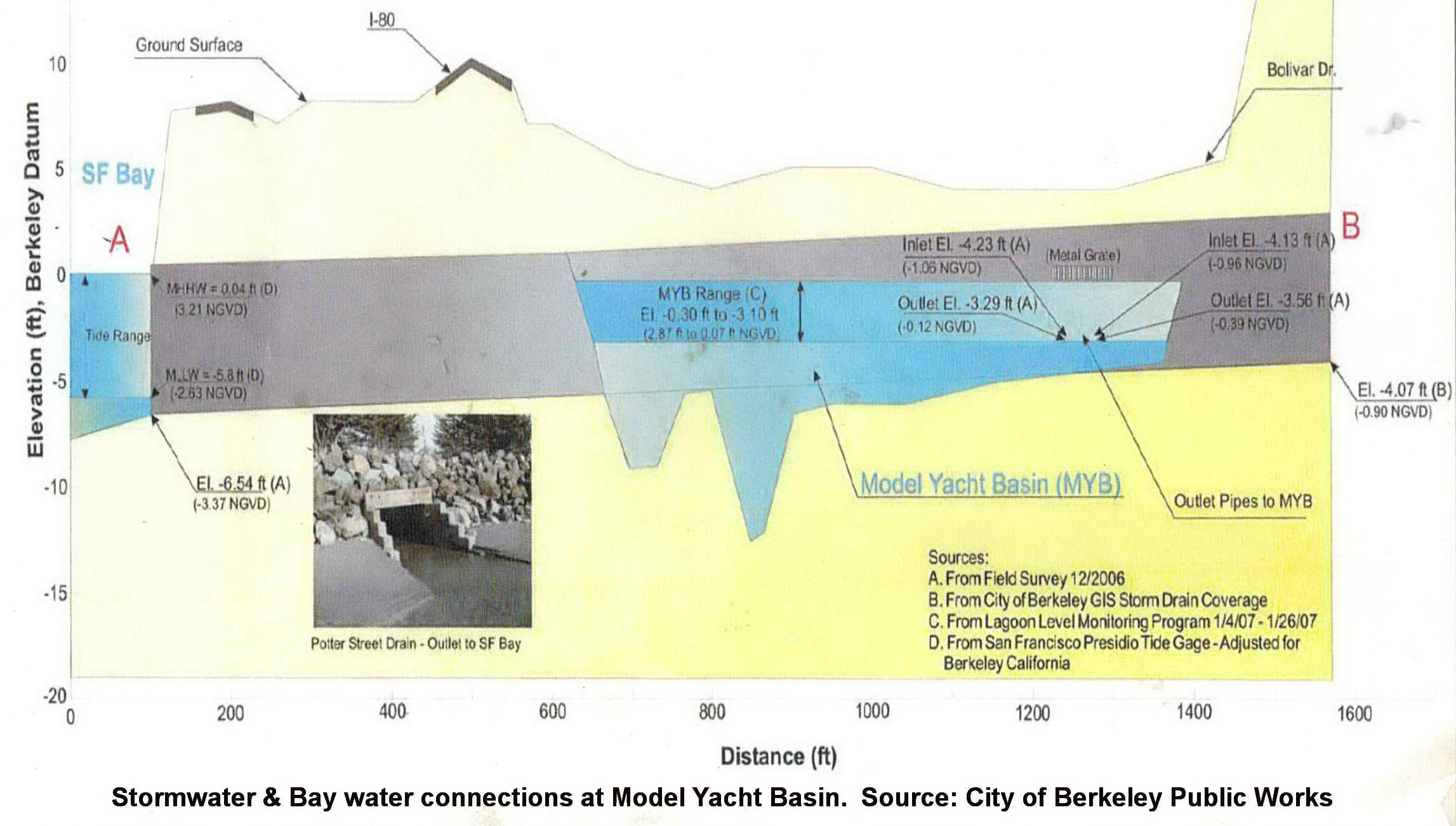
Click here to see a cross-section through the big drain, in relation to surface and tidal elevation. The diagram does not show water infrastructure that lies above the drain. We have been unable to get an explanation of this from the city.
The photos below show how water moves between the Potter Drain and Model Yacht Basin. at low water levels, flows move in and out by the two round openings in the big drain’s side, with no slide gates to limit it. When tides or storms raise water levels, water also fountains out of grates above the drain.
Clockwise from upper left: Left, during a low and falling tide, water flows from the lagoon into the Potter Drain via two round openings in its side. Center, flows power from these side openings during a rainstorm. Right and below: During high tides or big storms, the drain fills; water also fountains out of wide grates above the drain and over its terraced concrete roof.


The egret hunting in the photo above shows that exchange with the Potter storm drain has a silver lining. Bay water flooding into the lagoon brings fish and other Bay life. Fish-eating birds –herons, egrets, cormorants, gulls, pelicans, and more — gather to hunt. Frequent exchange with cool, salty Bay water also may be a reason that big algae blooms seem less common here than in the main lagoon, despite pollution from urban runoff.
A Model Yacht Basin increasingly filled with sediment will not be an effective outlet or emergency storage. As sediment fills the Model Yacht Basin, however, flooding in Southwest Berkeley may increase. The pipe, built about 1929, has been at capacity for decades — that is why Berkeley increased diversions into Aquatic Park in the 1950s. Higher high tides and larger downpours due to global warming also will make it more likely that water will back up and flood streets or buildings. A Model Yacht Basin increasingly filled with sediment will not be an effective outlet or emergency storage.
Berkeley paid contractors to update its plan for managing stormwater in 2024, but like many city projects, the effort is behind schedule, with no sign of the draft scheduled for spring 2026. Elements considering Aquatic Park are listed as optional and the city has declined to even do simple drone measurements of depths, although several other elements specified in the contract are not being done.
The Model Yacht Basin’s choked pipe to the Bay: Aquatic Park was built when the big Potter pipe still carried raw sewage, so the Model Yacht Basin was built to drain water in and out via a 24″ concrete pipe near the middle of its western shore. A corner of the pipe’s protective concrete box can be seen in the left photo below. As the photos show, this pipe’s lagoon-side mouth now sits well below surrounding sediment that also fills most of the pipe. The pipe’s Bay end (right photo below) has been buried in sand since at least 1990, apparently because local winds and currents pile up sand there. Some flow still muscles through, however, as the photo below right shows.


Photos at low water: Left, flows through the largely choked 24-inch pipe connecting the Model Yacht Basin and Bay appear to maintain a pit almost surrounded by a bar of sediment. The pipe box is at left. The smaller pipe may be an old drain from the freeway and is badly cracked. We have not seen inflow here, but it may occur. Center: At low water levels, the dark shape of the 24″ pipe looms below a small whirlpool of outgoing water. Inflows make a small turbulent rise, or boil. Right: On the Bay side at low tide, water bubbles up from sand that all but buries the pipe’s outlet. At very low tides, you can see this outlet, the stairstepped concrete mouth of the Potter Drain, and the Radio Tower pipe, all close together, from the Bay Trail between the parking in South Berkeley and Point Emery in Emeryville.
As the following sections show, the pollution, circulation, and flooding challenges described above also affect the main lagoon. There is no easy answer. Dredging would be expensive. Water could be forced through the Potter (or Strawberry) drain with pumps — many cities with low-lying areas do this. Alameda County Flood Control operates two dozen pumping stations, including in Oakland, San Leandro, and Alameda. Besides costs, however, these require maintenance — not a Berkeley strength. Power to operate pumps also can be lost in emergencies. And with its 24″ Bay connection largely blocked, this lagoon and probably the main one need the Bay water that now comes up through the Potter Drain.
Pipes between Model Yacht Basin and main lagoon: The Potter Drain’s big flows mean that water levels in the small (about 4 acre) Model Yacht Basin often rise and fall faster than in the main one. Water flows from a higher level to a lower one until they are equal, so this imbalance helps move water — and water creatures — between the two lagoons. But these pipes are largely blocked.
Two large concrete boxes jut from the north shore of the Model Yacht Basin. Each protects an 18″ concrete pipe crossing under Bolivar Drive to the main lagoon. The eastern pipe still carries significant amounts of water, despite breaks and siltation. At right, a current can be seen flowing from the east box into the Model Yacht Basin while water levels in the main lagoon were higher. Sometimes this current carries visible black sediment.

On the main lagoon, short pipes project directly from the south shore, without protective boxes. When water is higher in the Model Yacht Basin, you may spot a small whirlpool near the eastern box and vigorous upwelling flow into the main lagoon across the road. As with Potter Drain inflows, this draws fish-eating birds from terns to pelicans, hunting small fish that come with or are disturbed by the current. Besides fish and other creatures, this eastern pipe brings significant Bay and/or stormwater inflows from the Potter Drain into the main lagoon, despite ovious blockage.
Below left: In the main lagoon, a great egret and a much smaller cormorant, with snake-like neck, hunt in the boil welling from the Model Yacht Basin connection pipe. Below right: Flows into the main lagoon well up from what looks like a break in the pipe (red arrow) and the actual mouth (yellow arrow). The water’s force maintains a trench in sediments — the light-colored area edged by darker algae.


Left: Until fall 2024, the western pipe appeared completely blocked, with no visible flow at either end. Since then, a small current into the main lagoon has been visible when Model Yacht Basin water levels are higher (photo left). Perhaps tubeworms or other matter blocking the pipe decayed or came loose. Masses of dark green algae also now flourish near the pipe’s mouth.
Clearing and repairing these these pipes could increase flows, significantly lessening the stagnation and algae growth that plague this end of the lagoon.Another possibility is replacing the failing pipes with a single bridge. This has been suggested in several studies and plans, including a 2007 memo modeling possible improvements to water circulation and exchange between the two lagoons, part of the major, never-implemented Aquatic Park Improvement Study.
The main lagoon


The main tide gates: The mile-long main lagoon is busy with boaters, its edges popular for picnics, games, cycling, strolling, disc golf, wildlife watching, and more. Visitors’ enjoyment hangs on five tide gates (above) near the middle of the western shore, close to the waterski docks and across from the small island visible from the freeway. These gates lead to pipes that angle gently downward to empty at the Bay shore across I-80, a short way south of the long sandy beach. Most of the water that keeps the main lagoon from becoming a stagnant mess moves through these pipes and gates.
The pipes and horizontal openings in the gates keep lagoon water levels from fluctuting more than the desired range of about two feet. When tides in the Bay rise above the lower limit of the desired level, Bay water can flow in. Lagoon water below this level cannot flow out. Above this level, openings can be adjusted to allow more or less flow. For example, they can be closed more to slow inflow during extreme high tides, or opened more to let rain from big storms escape. This is done manually, and not often. Without this regulation, buildings near the shore would flood at high tides and boats would be stranded on mudflats at low ones.
Inflows bring levels of salt, oxygen, and temperature similar to those in the Bay, so that many of the same or similar plants and animals can survive and move between them. The restricted tidal range, however, combined with low circulation, brings a risk that water in deeper parts of the lagoon can become stagnant, with too little oxygen to support most life. It also allows many invertebrates that can’t tolerate tolerate big tidal fluctations flourish. This can have consequences.
The most obvious example has been Australian tube worms. These tiny, now worldwide “ecosystem engineers” secrete narrow protective tubes, with caps they can close or open to catch prey. Their dense colonies gradually all but filled the main lagoon’s pipes and ringed it with reefs attached to wood or rocks. Thus, they creating stable, tide-free conditions where they could flourish. But almost no tidal flow meant almost no water exchange and circulation. Algae and smells increased. Clearing them out of the main tide tubes in 2020 restored tidal fluctuations — but also killed the native oysters. As of 2025, both seemed to be coming back slowly.
The pipes are almost 90 years old. Their concrete and reinforcing metal are beyond their expected lives and in weakened condition. Collapse, for example in an earthquake, could close I-80 and flood roads and buildings around the main lagoon, as well as in nearby West Berkeley. Berkeley’s $5 million grant to clean and strengthen these and other connections, with no action so far, is described in the first section above.
The lost north outlet: The abandoned concrete box in the photo below still holds some of the machinery that controlled flow in the Depression-era builders’ northernmost pipe to the Bay. The Santa Fe Railroad, which traded the park’s wetlands for others so that the park could be built, blocked this pipe by filling its wetlands to the west in the 1950s and ’60s. Forty years of citizen effort, however, led to that landfill becoming the Brickyard portion of McLaughlin Eastshore State Park.
Some water may still seep through, into a ditch between the Bay Trail and the park. But restoring the connection seems unlikely.

Loss of this pipe’s circulation and exchange, along with shallow depths, are likely reasons for frequent “blooms” of scummy algae, diatoms, and bacteria in the lagoon’s north end. For more on the roles of algae, runoff, and circulation, see Change and Instability.
The Strawberry connection: Like the huge Potter pipe at Aquatic Park’s south end, the big Strawberry storm drain plays a complicated role in the north. The city’s second-largest storm drain roughly follows the old path of (mostly culverted) Strawberry Creek down University Avenue, reaching the Bay at a small cove in McLaughlin Eastshore State Park just west of the freeway. Draining close to a quarter of the city, this Strawberry storm drain can flood streeets and low-lying property when heavy rains or high tides fill and back up the pipe.
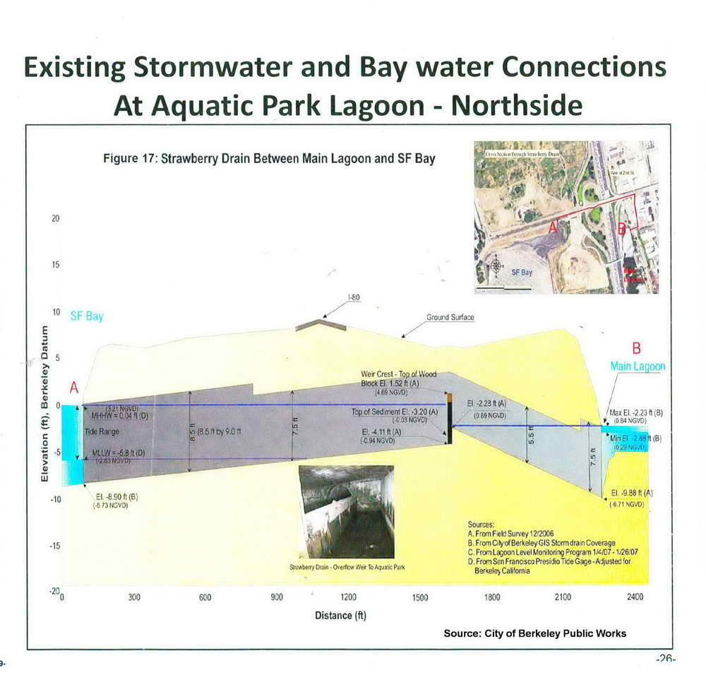
A buried spur to the main lagoon at the end of Addison Street helps avoid this. Click here to see a large City of Berkeley diagram of this spur, almost a half mile long and slightly larger than the Potter Drain at its upper end. Nearing Aquatic Park, it narrows and angles. Here a weir –a low dam designed to let water flow over its top — keeps the lagoon from draining northward into creek and Bay, while letting water enter the lagoon only when high tides or heavy storms almost fill the drain, threatening backups.
Water often can be seen boiling up from the pipe’s end at Addison Street when Bay or Strawberry Creek water is flowing into the lagoon. Birds lie in wait, dive, or hunt on the wing in and near these upwellings. Small silvery schooling fish sometimes flash as they jump. The inflows of clean, salty Bay water boost circulation and help make up for loss of the north end culvert. But they also bring sediment, and in storm season, polluted urban runoff from the city. In summer, the weir seems designed to trap stagnant water. These may contribute to the heavy growths of dark algae that commonly edge the pipe’s submerged end in the lagoon.
Below left: Cormorants dive for fish in the upwelling from the Strawberry Creek drain outlet at the north end of the main lagoon. Pelicans, herons, egrets, and terns also often hunt here during inflows, and flashes of tiny leaping schools of fish are common. Below right: The outlet pipe also often has heavy growths of algae.


Mini-watersheds along the east shore
West of Seventh Street, between the big Potter and Strawberry pipes, almost every street drains to the park. Farther east, drainage heads north or south to the big pipes. This leaves small, isolated watersheds, each carrying only a relatively small amount of runoff, but with significant pollution from 150 years of heavy industry and rail traffic. Some of this reaches the former Bay shore, now Aquatic Park, in pipes paid for or built by those industries. Others are springs of a kind: The railroad and land east of the tracks are about 8-10 feet higher elevation than the park, so the shallow groundwater of the flatlands finds its way under the tracks, emerging from the railroad grade — once the shoreline bluff — to form wetlands and creeklets winding to the lagoons.

Left : In this map from Berkeley’s 2019 Green Infrastructure Plan, red and orange show high potential for reducing pollution from PCBs. Widely used to insulate equipment since the 1930s, persistent PCBs harm people and wildlife and usefully indicate other industrial pollution. The plan identified most street ends at the railroad as places where absorbent bioswales and rain gardens could filter and absorb some of this.
The map of city drain infrastructure at left shows how West Berkeley streets along the southeast shore of Aquatic Park formerly drained to the Bay. Red lines today are sanitary sewers. Carrying waste from toilets and sinks, they were intercepted by EBMUD in the late 1940s to early 1950s. Sewage goes to EBMUD’s treatment plant near the Bay Bridge. Brown lines show storm drains, handling rain runoff and a soup of other pollutants.
The transite pipe: On the map above, the brown line close to the main lagoon’s east shore from Parker Street south is the “transite” pipe. Transite is a hard, durable concrete made with asbestos into the 1980s. Berkeley installed this paralleling the shoreline in the 1970s, after the Regional Water Quality Control Board ordered that stormwater be kept out of Aquatic Park’s lagoons. The aim was to intercept street runoff and send it to the Bay via the Potter storm drain.
This has proved somewhat effective for small rains and moderate tides. But since the 1950s, the city has sidetracked Potter pipe flows into the Model Yacht Basin, so some runoff goes into the lagoons.
The Potter pipe also has been at capacity for decades: During large storms and very high tides, water cannot get out to the Bay and backs up, threatening to flood south and west Berkeley. When the wide-open side exits to the Model Yacht Basin don’t let enough water out, it backs up into the transite pipe, which may be full already. It fountains and jets out of the century-old sewer infrastructure at least as far north as Carleton Street. This is likely to become more common global warming brings higher sea levels rise and larger storms.
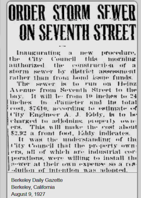
Heinz Street: In 1927, heavy industries clustered just east of the railroad tracks paid Berkeley to build a sewer to the lagoon. In 1952, the (then) Southern Pacific Railroad gave Berkeley a 10-foot-wide easement for a storm-sewer pipe through the railroad right-of-way at both Heinz and Grayson, the next street north. (These may e the same pipes that formerly carried sewage, now intercepted y EBMUD.) Left below: During high tides or storms, water shoots forcefully and noisily into the lagoon from the mouth of the old 24-inch sewer pipe, usually almost hidden in the vegetation. Right below: Antique infrastructure below the railroad grade, including old tank and deep vaults with metal covers. Until they were somewhat flimsily strapped down in late 2025, some of these covers were dangerously easy to remove.
The city’s Green Infrastructure Plan recommends a bioswale or other feature to filter out pollutants, especially PCBs, here. It was listed but not funded as a capital project in the city’s 2016 Measure T-1 bond issue.


Grayson Street: Green infrasructure at Grayson Street also was planned but not funded as part of Berkeley’s 2016 T1 capital improvements bond measure. Also, as noted for Heinz Street, in 1952 the railroad gave Berkeley a 10-foot-wide easement for a storm-sewer pipe here, perhaps clarifying permissions for the former sewer pipe after EBMUD intercepted raw sewage. Left below, outflows from the big old industrial pipe below Grayson Street during a large storm and very high tide. Right below, top: A gulch in the sediments at the mouth of this old pipe remains all year, perhaps indicating strong flows not from storms or tides. Right below, bottom: Water fountains out of old infrastructure between Grayson and the tracks during a large storm.


Pardee and Carleton Streets: By state law, property owners may reclaim and close streets if they own land on both sides and a through right-of-way is not needed. Bayer Corporation closed Pardee Street to Seventh when it bought the old Colgate Palmolive Peet plant in 1999, and Carleton’s end after buying all of both sides in 2024. In turning over Carleton Street, Berkeley got a verbal promise that Bayer would do something to reduce runoff pollution here, but this may not be enforceable.
Below left and center: What happens to storm runoff in these mini-watersheds is not clear. On the lagoon side of the tracks west of Carleton, a dilapidated tank and vault are part of old infrastructure probably built when sewage flowed to the Bay, before Aquatic Park was created during the Great Depression. The center photo also shows a creeklet that often overflows the path here. This water may go to the transite pipe, which ends just north at Parker. Below right: The pipes near Carleton and Parker were under repair, with open excavations, from at least July 2025 to May 14, 2026, when park staff finally replaced the park’s broken drinking-water line. This may have ended the overflows at Carleton; the next rainy season will tell.


Parker Street — end of the transite pipe: A 24-inch concrete pipe barely visible on the lagoon shore (photo below left, with arrow), concrete pads by the path, and other infrastructure (photo below right) mark the north end of the transite pipe, built to take runoff from West Berkeley mini-watersheds to the big Potter outfall to the Bay. The plumbing here may be more then a simple pipe. Cutter Laboratories, now Bayer, had expanded and closed first Fifth and Sixth between Dwight and Parker, and then Parker itself in 1941. In trade, Cutter deeded Berkeley a 10 ft. sewer easement and some land west of the railroad tracks here. A sizable creeklet flows and overflows to the Bay nearby.

Parker, Cutter/Calco Way, Dwight: Springs, wetlands, creeklets. As this is written (June 9, 2025) the railroad grade and east edge of Aquatic Park from Heinz to north of Dwight Way has been transformed. Beginning May 12, Union Pacific Railroad removed a significant amounts of vegetation to rehabilitate disused tracks.
Berkeley missed the notice of meetings to discuss this project. It found out in April, with work scheduled to begin, that plans had been approved by Alameda Countywide Transportation and Regional Water Quality Control Board a year earlier. These included removing tall eucalyptus trees along the tracks and three holes of the park’s popular disc-golf course.
Hasty meetings that followed led to adjustments ,ore or less on the fly. The railroad promised Berkeley significant sums to re-plant and create relocated disc-golf holes. The tall eucalyptus trees, dangerous for passing trains, are gone, along with the thick vegetation that hid the big industrial buildings that were the park’s neighbors east of the tracks.
Plans approved by the Regional Water Quality Control Board appear lacking, full of obvious errors carried over from drafts done by railroad planners in Omaha. For example, the plans recognize only one of four or more creeklets (depends how you count). Headwaters of two are now a muddy mess. The spring of the one recognized creek has been buried under wood debris. There appears to be no serious plan for revegetating or even protecting bare, machine-disturbed slopes; the railroad application certified, or approved, by the Regional Board asks the railroad to rehabilitate only to the standards of a less than a dozen unflattering photos years old. The park’s edge for years to come is likely to be the industrial buildings that the volunteer vegetation hid. There appears to be no plan to maintain what is being done by either the railroad on its land or the Berkeley Parks Department in the park. Please check for updates!
The photos below are a sampler of varied wetlands amd creeklets as they were: cattails and tules, ivy and blackberry thickets, groves of young willows, huge old trees, grasses and sedges, mucky spots, and deep pools. This was neglected and not paradise.


Green infrastructure at Dwight and Channing
Berkeley installed bioretention basins, sometimes called rain gardens, at the west ends of Dwight (below left) and Channing Way (below right) just east of the railroad tracks. The idea is a sunken area where pollutants pond and soak in, usually in special soils and layers of gravel. Pipes take excess water to storm drains and prevent flooding. At Dwight, there are records of pipes allowing this flow under the tracks.


The Channing rain garden evidently didn’t do the job. The City of Berkeley applied for, and got, a $1.5-million grant from the U.S. Environmental Protection Agency to pay half the cost of a centrifugal trash separator at the street end, plus a 10,000-square-foot rain garden in the park below (map left). Construction must start by 2027.
Berkeley appears to have funds for its share from dedicated stormwater fees, plus more than $1 million settling a multi-state lawsuit for damages from PCBs — the major targets of the city’s 2021 Green Infrastructure Plan.
As of late May 2026, the project is in the city’s draft budget, scheduled to be done on time.
Bancroft and Addison: Effects TBD from two new blocks of empty lab building

The Berkeley Commons lab development, stretching from Bancroft to Addison, and railroad tracks to park, has sat without tenants since its 2024 completion. Despite measures to reduce runoff pollution, the end of Bancroft now floods regularly at any significant storm (photo left is typical). Addison also floods, but less.
Did the new building increase pollution to the lagoons? When these street ends flood, more polluted runoff flows directly to the lagoons. The increase may be due to an actual decrease in the area where water can soak into soil. According to plans in the Regional Water Quality Control Board’s SMART database, permeable areas on Bolivar Drive shrank from 0.81 acres before the project to 0.65 acres afterwards (out of 2.23 acres total). This part of the project did not have to meet requirements for improving stormwater treatment because it included a new bicycle and pedestrian path. It did add attractive green areas and permeable parking.
On the main site’s 8.36 acres from Bancroft to Addison, permeable areas increased from 0.59 to 0.79 areas, but most of the site had been used to store heaps of soil, gravel, and rock. More than half — 4.60 acres — was described as “compacted soil,” where some rain probably did soak in. All of this is now classed as impermeable.
North of Addison: The Strawberry Creek connector, Berkeley’s Dona Spring Animal Shelter, and possible freeway connections (in progress)
Berkeley’s Dona Spring Animal Shelter, completed in 2013, boasted a green roof and lovely rain gardens intended to filter runoff to the lagoons, as well as parking surfaces that let some rain soak in. The rain gardens were neglected, and when a truck destroyed much of the plumbing system, no repairs were done for several yeras. They have been partly restored and are getting better maintenance, again contributing their bit for this end of the lagoon, plagued by algae with its original exchange pipe blocked decades ago. Below left, green roof from University Avenue overpass; center, rain garden 2014, right, partky replanted 2026.


