The quick slide show below is the most recent update. Working on making it more readable.
In a nutshell: Much more clearing has been done, with wood massed on the embankment above unprotected wetlands and small creeks.
A public-records request yielded a great deal of background. What seemed to be the plans were replaced in June 2024 (!) with new versions, which were approved by state and federal agencies and Alameda County’s Transportation Commission. Berkeley, having missed notifications, knew nothing of old or new versions.
These plansrecognize only one creeklet as existing. The little they require in the way of “rehabilitation” will be based on a handful of photos taken by the railroad in 2022 or earlier.
The Regional Water Quality Control Board has known for some time that what amounts to a typo (they confused San Francisco’s and Berkeley’s Aquatic Parks) means there is no official record that the Aquatic Park lagoons have impaired water quality. This limits enforcement action, not just for the railroad. Nothing has been done.
This is the May update:
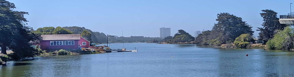
History: Aquatic Park and the Transcontinental Railroad: The transcontinental railroad reached Oakland via Niles Canyon in 1869. The Central Pacific, later Southern Pacific and now Union Pacific Railroad (UPRR), almost immediately began building northeast toward Sacramento as well as south toward Los Angeles. By 1878, as the town incorporated, freight tracks were pushed through on what is now Third Street, close to the waterfront. Along most of the length of today’s Aquatic Park, tracks ran directly on the low coastal bluff.
This led indirectly to the park’s creation more than 50 years later. Because the tracks cut off the waterfront, the Eastshore Highway feeding the new Bay Bridge — the Bay Area’s largest Great Depression public-works project — had to be built on fill offshore. Aquatic Park was a hasty fix to to keep this cutoff finger of Bay from becoming a stagnant cesspool of industrial and human waste.
The railroad’s right of way, hugged by vital buried pipelines, extends down the steep slope well into what most people think of as park. Shallow groundwater percolating through the slope waters trees and bushes. These hid industrial buildings east of the tracks. Visitors and city officials came to think of the right of way as park — until a jarring wake-up.
The railroad takes back its land: Disc golfers sounded the alarm in early April 2026, when notices and construction stakes threatened three of their “holes” — and their scheduled annual fundraiser.
Berkeley had overlooked notice of the meetings that led the Alameda County Transportation Commission and Regional Water Quality Control Board to approve, back in December 2024, the railroad’s plans to rehabilitate a disused set of tracks here. Aquatic Park work is a small part of a larger project: In the highly urbanized East Bay, the park south of the Dreamland for Kids playground is one of the few places where extra tracks offered space for trains to wait or be reconfigured during rebuilding of the 7th Street underpass to the Port of Oakland, a major bottleneck. That project is expected to take several years.
Hasty meetings — with park users, advocates, and agencies — led to a settlement that may not yet be written (as of late May 2026).
- Planned environmental mitigation was shifted to Aquatic Park from the edge of Target’s parking lot in Albany. Through grants and direct payment, Berkeley will get about $200,000 for around 1000 new trees and other plants, plus replacement disc-golf facilities. Youth interns at Waterside Workshops will help with planting and maintenance.
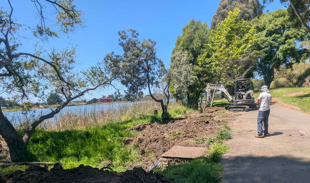
- The railroad did much of its clearing in mid-May, removing the tall eucalyptus trees and other vegetation close to the tracks. Access for the work through the Bayer campus east of the tracks (keeping most out of the park), and keeping the tracks closely spaced, was already planned.
Thus for park visitors, a ragged fringe of vegetation and bare spots now reveal big industrial buildings. Photos below show the park near the foot of Dwight on May 3, before clearing, and May 15, afterwards.

This example is extreme. But significant environmental unknowns and questions remain:
- Loss of the eucalyptus, as in the photos above, means loss of trees used by herons and egrets, raptors and songbirds, and migrating monarch butterflies. We have no information on whether anyone checked for nesting birds. These species generally have no special legal protections. critical infrastructure has exemptions from many environmental requirements. And tall trees next to passenger trains are not a good idea. New trees, if maintained, could eventually be better habitat.
- By missing the planning process, Berkeley may have missed a chance for mitigation that would get rid of antique sewage infrastructure, including dangerous deep tanks, or lessened the impact of legacy pollutants such as PCBs, heavy metals, and hydrocarbons from former West Berkeley heavy industry and the railroad tracks themselves. Plans so far do not mention dust control or other reduction of this legacy pollution. Click here for advocates’ letters with background on these issues.
- Plans do not seem to expect great success from re-planting. For a much smaller area, the Regional Water Quality Control Board’s approval requires that half the trees survive after ten years, and allow up to half of all vegetation to be invasive and up to a quarter of the area to be bare after five years. This may be realism. In Aquatic Park, the Parks Department has mowed two previous grant-financed restorations of native plants into oblivion, and native wildflowers and grasses seeded as required by the Board were overrun by weeds within two years. As the railroad work went on, Parks staff fixed a broken water main that had been leaking for eight months — leaving a large area of bare soil a few feet from the main lagoon’s edge.
- The railroad’s approved plan has significant inaccuracies and has not been followed (see key section below). Only one creeklet is shown flowing from wetlands to the lagoon, with careful protection promised. However, at least four more such creeklets flow from railroad land to the lagoon farther north in the project area, none of them mapped. The section below also shows that railroad work should stay out of the wetland areas north of Carleton. Tree and brush removal, however, trashed the marshy headwaters and springs where most of these creeklets originated. Promised protection against erosion and siltation is inadequate or missing.

Above: Left, trashed headwaters of a creeket south of the foot of Dwight Way. Right, railroad proposed plans for the project north of Carleton, showing no creeklets and no work in wetlands. (See June 12 update aabove. These have been replaced by new, approved that recognize less wetland and promise far less rehabilitation for disturbance.